@LüDi
Did you try Cura taking charge of the tool offset?
Using offsets in RRF is a bit counterintuitive regarding the +/- sign of the offset.
Check out the G10 L2 or G10 L20 description. It might give you another option to make it work.
Posts made by o_lampe
-
RE: Dual Extruder on Polar Printerposted in General Discussion
-
RE: Closed loop firmware for CNCposted in CNC
AFAIK, the current closed loop strategy in RRF is to add the missed steps to the axis involved. But that could end up very bad on CNC machines.
Slowing down the other axis' would be the safer way, but with a buffered path planner it's still not in real time. -
RE: Dead driver or dying board?posted in Duet Hardware and wiring
@kazolar I ruined my CNC frame with a similar problem. One Y motor stopped and skipped steps, the other went on.
To avoid that once and for all, you should add an "anti racking" mechanism.
Maybe couple both motors (dual shaft motors preferably) with a shaft extension or do what is common in big machines: add a cord/wire to the crossbeam to eliminate racking.
Check out the first few pages of my hashPrinter thread, where I used that method a lot. There are also some links to my Youtube channel, where I demonstrate the anti racking effect.PS: If you want more people to read your wall of text, you should edit it for better readability.
-
RE: Integrating AI with 3D printerposted in 3D Printing General Chat
This smells like ChatGPT BS.
OTOH, a bit more autotuning in some areas (pressure advance and input shaping) coming from a local PC or SBC would be nice.... -
RE: Spirograph emulator with Duet2posted in CNC
@mrehorstdmd Currently I'm using Sandify, but I can also produce gcode from .dxf files. With inkscape I could theoreticaly use any bitmap to generate patterns and I could manually drag every knot of a path out of the zones.
I used it frequently, when my K40 laser was new.I haven't thought to look elsewhere, but if others (CNC or laser scene? ) have the same problem with keep out zones, I'd be happy to know.
Is the PERL post processor open source? I'm looking for a good starting point to write my own.(open file, modify gcode lines, write new file) -
RE: Spirograph emulator with Duet2posted in CNC
@droftarts said in Spirograph emulator with Duet2:
I'd say it was rare to design a machine with the axes inside the build area.
You're right, but I wanted the footprint of the table aka delta tower-triangle to be small.
I got a nice 38cm dia glasstable with a predrilled footprint of 320mm. I'll have to place the towers accordingly.
@droftarts said in Spirograph emulator with Duet2:
Currently only one keep out zone is supported
Guess, I have to write a postprocessor which takes care of three keepout zones and doesn't quit the job.
-
RE: Spirograph emulator with Duet2posted in CNC
Just found out that M599 can define keep out zones. But searching for "keep out" in the Wiki gave no result...
Bad news is, it only works on Duet3 boards due to RAM restrictions.Guess I can build a few sandify patterns, that match such an odd working area, but wipe-patterns usually apply to rectangular or polar areas only
-
RE: Spirograph emulator with Duet2posted in CNC
The Slim Delta is alive and I could reach areas outside of the triangle.
The problem is, how do I tell RRF that it mustn't foul the towers?
I know there are people using that for their leadscrew area and such, but I couldn't find it in the Wiki.
-
RE: 3-phase 2-pole CPAP pump with 6HC?posted in Duet Hardware and wiring
@gnydick These controllers require hall sensors. I couldn't find info about them in your motor sheet.
If it comes with hall sensors, you're probably good. (400W seems an awful lot for these small controllers)
If not you can try rc-hobby ESCs. They work without halls, but need a "hobby-servo" compatible signal. RRF can send that, too. It's just a matter of declaration. -
RE: Sovol SV08 Multiple Motion System Upgrade.posted in My Duet controlled machine
@dwuk3d said in Sovol SV08 Multiple Motion System Upgrade.:
Plus a more serious issue.
I might have to do with endstop offset adjustment.
-
RE: 3-phase 2-pole CPAP pump with 6HC?posted in Duet Hardware and wiring
@gnydick Looks like a candidate for simpleFOC.
I've integrated brushless motors in RRF with their step/dir interface to emulate steppers, but for a blower it would also be possible the use PWM, like an ordinary fan-port.
They recently have introduced a controller big enough for 30A motors, but IMHO it's not recommended for simpleFOC newbies.
I just checked their shop and it's not listed yet. But ask in their forum and you'll be heard. -
RE: Extruder best at extruding?posted in 3D Printing General Chat
@3DPMicro I'm in the same boat, not knowing what's out there.
IMHO all these geared extruders have the same issue: motor cogging and gear ratio sum up to an uneven torque curve. That's partly because of straight-cut gears, but also the gear ratio can amplify motor cogging into a regular pattern. Using prime numbers for gears would eliminate this.IMHO (biased) the screw extruder is one of a kind, because it doesn't use gears and the steps/mm are so huge, you can use very small and light motors.
-
RE: Spirograph emulator with Duet2posted in CNC
@mrehorstdmd said in Spirograph emulator with Duet2:
M98 P"/gcodes/^{random(212)}^.gcode"
Basically, that's what I'd try too.
But I'd check, if the file (still) exists before I call M98. Unless you only put files in the gcode directory after you tested it. It would be a PITA to e.g. rename files 123-212 , just because file 122 turned out to be problematic or ugly or boring.Alternatively you could edit the unwanted file and only leave the end code. The worst that can happen is running two wipe-file in a row.
-
RE: Spirograph emulator with Duet2posted in CNC
@mrehorstdmd A SCARA arm in the center would be nice, but I don't know if RRF supports the 360° working area? @dc42 @JoergS5 ?

The design is 7 years old, I wonder if there are improved designs available, a counterweight would be nice IMHO. -
RE: Spirograph emulator with Duet2posted in CNC
@mrehorstdmd I guess, the homing sequence is never the same, depending on the starting points of the axis'. When you call
randomafterwards, the seed will be different. -
RE: Spirograph emulator with Duet2posted in CNC
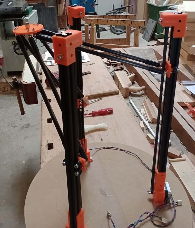
Here's a rough sketch of a SlimDelta which works upside down.
Motors and extrusion are mounted inline, which will free up the print-area.
I hope I can get away with NEMA14 motors (0.4Nm) because the effector + magnet weight is so low.
Long rods and narrow triangle will give me the biggest print area, accuracy is not important here. The magnet will drag the ball along, even with a few millimeters gap between.
-
RE: Spirograph emulator with Duet2posted in CNC
@mrehorstdmd Good point. I thought the miracle behind the infinity trick is the semi-transparent top-mirror, but with sand at the bottom it won't work.
Glad I didn't order it")
-
RE: Spirograph emulator with Duet2posted in CNC
I'm still pondering how to build the frame. It should not be much bigger than the glass plate and still reach (almost) everywhere.
The best kinematic option we already have is the delta: I could turn around the delta effector to show upwards and the three towers would act as table-feet.
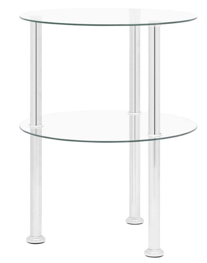
I just have to find round glass plates and build a sandwich. (bottom plate could be dibond as @mrehorstdmd suggested)<edit> looking for glass tables I stumbled across this round infinity table
How cool would that be in combination with a sandtable?!

-
RE: Spirograph emulator with Duet2posted in CNC
@o_lampe said in Spirograph emulator with Duet2:
Another question is related to Meta commands/macros:
What I got so far:
- I rename all the patterns with numbers
- I add a subdirectory for wiper/eraser patterns
- I choose the next pattern by a random generator and filter out nonexisting numbers with
if exists - after each pattern, I call a random wiper pattern and vice versa
That way I don't have to know the exact number of existing patterns
-
RE: Spirograph emulator with Duet2posted in CNC
Another question is related to Meta commands/macros:
Is it possible to read out the total number of gcode files on the SD-card and run them randomly?
A macro call at the end of each gcode file would select the next...